Trip Report: Washington Cascades Overland Tour 2007 – Day Three (08.12.07)
Day Three: August 12, 2007.
Daily Goal: To Drive from near Blewett Pass (Cle Elum) to Chelan, Washington.
Map Reference:
Wenatchee National Forest Map
Today, I awoke to what sounded like raindrops landing on my Land Cruiser. I looked out, sure enough, it was raining. This was a perfect time to see if I could roll up my sleeping and air mattress as well as rearrange the refrigerator and my gear before even stepping a foot outside. Success. It was actually easier once I got over the fact that there is limited headroom. After my morning routine, I was on the road again for the days adventure.
From my campsite on FS-9738, just west of Highway 97, it was a short 15 minute trip to the highway and another short three minute drive on the highway until I reached FS-9705 (Durst Creek). In all my years of living in the Washington state, this was only my second time of visiting the area between Liberty and Wenatchee. I followed FS-9705 for about 5.4 miles until it joined the main Liberty area road FS-9712. Along the way, I saw a flock of wild turkeys and and a small herd cow elk.
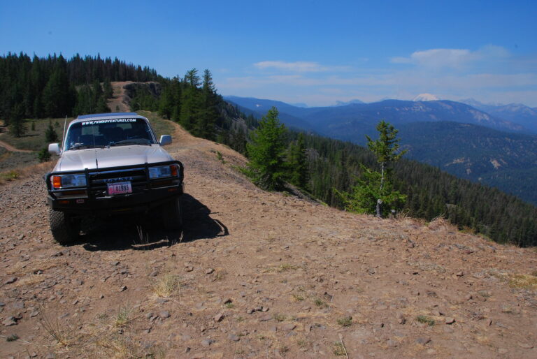
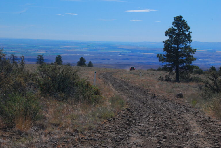
FS-9712 is a well maintained road until you reach Haney Meadows. After that, it becomes the type of road I enjoy to drive, limited maintenance, and high clearance vehicles only. FS-9712 basically follows the ridgeline, with a good portion above 5550 feet in elevation. From the ridgeline, you would see into the Wenatchee River valley, including the Columbia River and beyond.
After about 24 miles and 2.5 hours on FS-9712, I reached FS-7100. FS-7100 basically follows Mission Creek down into Cashmere, first on state and private land, and then back to national forest. The trip from FS-9712 to where the pavement began just outside Cashmere was about 12 miles and took about 40 minutes to travel.
Once I fueled up and bought my favorite coffee drink, I headed directly across Highway 2 to the Nahahum Canyon Road (which eventually becomes FS-7412) which I planed to travel to reach the Entiat River. After driving up the canyon five miles to where the pavement ends and the gravel begins was posted a sign, basically stating that due to extreme fire danger, this road was closed by order of the Chelan County Commissioners and it was strictly enforced by the Chelan County Sheriffs Department. I debated for a moment and decided that I would find an alternate route and not risk getting a ticket. So I headed back down the road back to to Highway 2 and drove to Leavenworth.
Once in Leavenworth, I stopped at the Forest Service office, but of course being on a Sunday, it were closed. Luckily I spotted a Forest Service employee pulling in behind the office with “Fire” marked on the truck. Just the person I needed to talk to. After a short conversation, I found out that all Forest Service road are open to the public and that Chelan County only has jurisdiction on closing county roads and not federal roads. Thats all the information I needed to continue my adventure. The last thing I wanted to was abort the trip or have to drive the highways to reach Okanogan County.
So after looking at my maps, I found a road that connected up to my originally planned route. From Leavenworth, I headed north up the Chumstick Highway until I reached Eagle Creek Rd. After about 6 miles, I reached FS-7520, back on my original route, only with a slight unnecessary detour. From FS-7520, I would first follow FS-5800 and then eventually FS-5700 through the Entiat Mountains until I reached the Entiat River Rd. (22 miles/1 hour travel time).
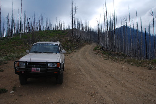
While driving up the Entiat River valley, I encountered the first of many areas of previous wildland fires that I would encounter over the next two days. The Entiat River Rd. eventually becomes FS-51. From FS-51, I followed FS-5900 (Shady Pass Rd.), through the Chelan Mountains, over Shady Pass and reaching elevation of +6000 feet in elevation, until I reached Lake Chelan. Along the way, I could see and smell the smoke from the Domke fire that was burning. As I descended towards Lake Chelan, the smoke had settled into the valley and had limited the views. Just before reaching Lake Chelan, I passed the Incident Base Camp for the Domke fire including a helibase with a Chinook helicopter parked for the night.
Once I reached Lake Chelan (27 miles/just under 2 hours travel time), I followed the lake until I reached the city of Chelan where I fueled up the Land Cruiser for the next leg of my adventure.
From Chelan, I headed north out of town towards Manson. After passing Wapato Lake, the road becomes FS-8200 and passes Antilon Lake. Just before the lake is Upper Joe Creek Rd/FS-8210 (which I totally missed on the way up) which eventually winds it way up to Cooper Ridge. After a short distance of driving Cooper Ridge, I drove up the spur road to the site of the old Cooper Mountain Lookout. Since it was getting late in the day, I decided that I would spend the night here. Elevation approximately 5800 feet.
The view to the west were good considering the smoke from the Domke fire filled the valley below. After setting up for the night, I was able to spend some time experimenting with my camera, including sunset shots (the reason why there are so many shots of this area).
Daily Summary (including some detours):
Total Miles Driven (approximate) – 201 miles (Blewett Pass to Cooper Mountain)
Paved Highway: 37 miles
Paved County Roads: 57 miles
Gravel Forest Service Roads: 108 miles
See all of the photos from day three of this trip at Washington Cascades Overland Tour 2007 – Day Three Photos.
Next Day: Day Four: Cooper Mountain Lookout (Chelan) to the British Columbia border at Chopaka
Trip Report: Washington Cascades Overland Tour 2007 – Introduction
Trip Report: Washington Cascades Overland Tour 2007 – Day One
Trip Report: Washington Cascades Overland Tour 2007 – Day Two
Trip Report: Washington Cascades Overland Tour 2007 – Day Three
Trip Report: Washington Cascades Overland Tour 2007 – Day Four
Trip Report: Washington Cascades Overland Tour 2007 – Final Thoughts