Below the Snowline: Huckleberry Creek/Greenwater – 5.19.2007

Winter on the West Slopes of the Cascades usually lasts well into Summer, with many places not being snow free until late June or even early July. With the recent summer-like weather in Western Washington, I desired to see how high the snowline was at this time of year.
So I set off for another day of exploring. This time, the rest of my family decided to stay home and do other things. Only the dog was anxious to go, as always.

From my home, I headed east on Highway 410 towards Mt. Rainier. I knew Chinook Pass wasn’t open. I was hoping that Highway 410 may be open to the White River Ranger Station in Mt. Rainier National Park. As soon as I arrived at Crystal Mountain Boulevard, I saw that Highway 410 was close to vehicle traffic, even though no snow was present. Several bicyclists were riding past the gate despite the steady downpour of rain. I’m sure the Washington State DOT is working hard to get Chinook Pass open by Memorial Day.
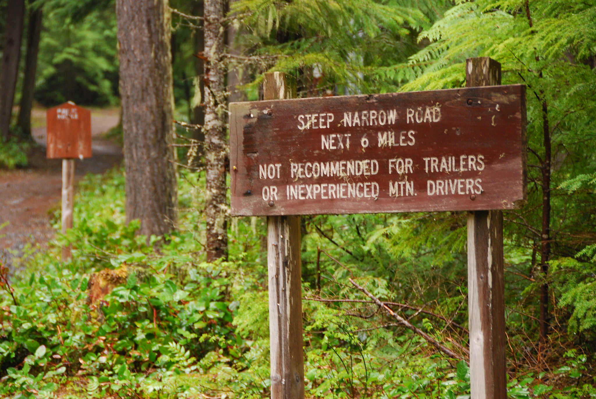
The next road I wanted to check out the conditions on was Corral Pass Road (FS 7174) which is just west of the Silver Springs Campground. Within one mile from the highway, there was a gate closing the road. Off to the next destination.

I had better luck on the next road system I explored. A little further west on Highway 410, I headed up FS 73 (just west of the Dalles Campground). After crossing the White River, FS 73 started following the valley floor. A short distance later, I followed FS 7315 toward Suntop Mountain (an old lookout site). The road steadily climbs out of the valley on a well maintained gravel road. The road was snowed in at about 3.5 miles up FS 7315 (4068-foot elevation). I took a quick break, turned around, and headed back down the hill to FS 73.

Once I got back to FS 73, I continued up the road. FS 73 gradually climbs, following Huckleberry Creek up the valley. Once FS 73 crosses Huckleberry Creek, the road begins to climb more steeply, passing several rock falls and downed trees (nicely cut up) along the way. There are some great views along the way. About 8 miles from the highway, the road was snowed in (4170-foot elevation). There were several vehicles parked, and I had to turn around. I’m sure they were having a fun time hiking in the snow. From the best I could determine, I wasn’t too far from where FS 73 crosses Eleanor Creek. At this point, I was probably only about a mile (in a straight line) from the actual boundary of Mt. Rainier National Park. From this point, I headed back to Highway 410.

The next area I wanted to check out was FS 74, which follows the West Fork of the White River just outside the Mt. Rainier park boundary. Less than a mile from Highway 410, a gate was closing FS 74. I’ll have to visit this area later in the year (if the damage from the 2006 floods weren’t too bad).
Time for exploring was running short, so I decided my last area would be FS 70 out of Greenwater, Washington. This area is very popular for four wheel drive and motorcyclist enthusiasts because of the area’s ORV trails, including the Naches Trail. When snow free, a person can follow FS 70 to where it crosses the Cascade crest (FS 7080) and drops into the Little Naches River drainage and FS 19.

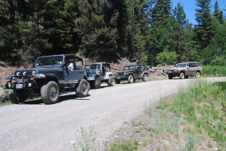
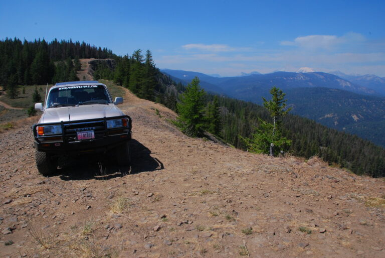
FS 70 begins as a nice paved forest service road following the Greenwater River. At about four miles from Highway 410, the road switchbacks up and back down the hill to where it meets with the river. At about 10 miles from the highway, FS 70 turns to a well maintained gravel road and begins to climb. There are some great views of the local peaks and valleys below along FS 70. About 14 miles from the highway was as far as I was going because of snow. At this point, I met up with a few people with their 4x4s, getting one of their rigs unstuck. A small world it was because I ended up knowing Brandon, who was driving the buggy (I later found out from his friend Jim that this wheeling trip was Brandon’s bachelor party – congrats and good luck, Brandon). This was also a great opportunity to practice taking pictures of vehicles, so I fired away a few shots.

After chatting and taking a few more photos on the way down the highway, it was time to head back home. Another fun day exploring in my Land Cruiser.
Happy Trails.
You can view more photos from this adventure by visiting Huckleberry Creek/Greenwater Area Photos.